Summary
Experience the photographic opportunities year-round at the tallest dunes in North America. While the dunes are the centerpiece, the preserves are a diverse landscape of grasslands, wetlands, conifer and aspen forests, alpine lakes, and tundra offering photographers a plethora of photo opportunities. At night photographers can enjoy a startling starry sky on moonless nights or capture the surreal blues in the dunes under bright full moonlight. This guide will help you explore those opportunities.
Location
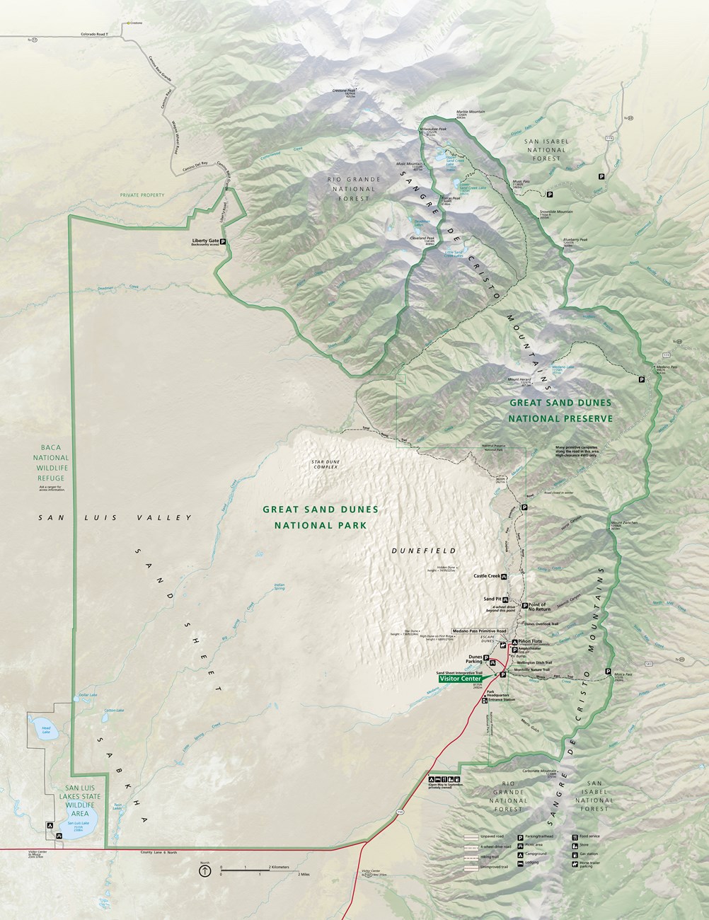
The preserve is located in an Eastern curve of the Sangre De Cristo Mountains adjacent to the Rio Grande National Forest to the North and Southeast, the San Isabel National Forest on the East, the Zapata Ranch on the South, the San Luis Lakes State Park and Wildlife Area, the nearby town of Alamosa on the Southeast, and the Baca National Wildlife Refuge to the West. The below National Parks Service map is a good resource for planning your visit.
GPS Coordinates & Elevation
Grid: 37°44’22.36″N 105°31’2.08″W Elevation Range: 8,200 to 13,604 ft Google Map Link
Best Time of Year to Shoot
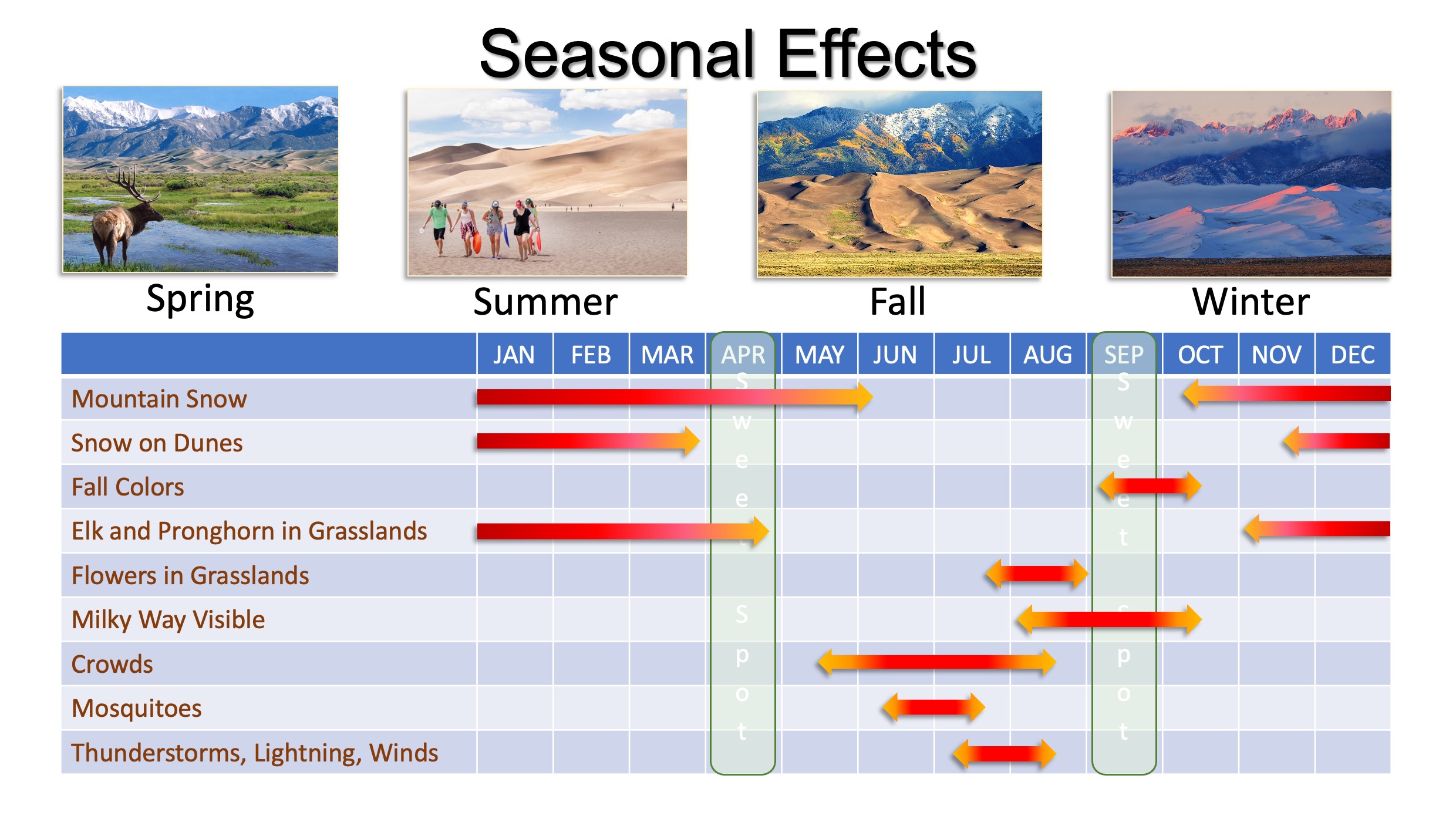
You can shoot this location year-round if you are trying for shots of the dunes only. However, the park itself has good wildflowers from late spring through mid-summer, and the mountains surrounding the dunes have a few aspens that change colors in the fall. Winter and spring can also be a good time to visit where you’ll find snow covering the surrounding peaks. Based upon the season effects, April and September months appear to be optional for landscape and nature photography, unless you are there pursuing other photographic interests. The following chart also points out some weather and bug issues that photographers should be aware of.
Best Time of Day to Shoot
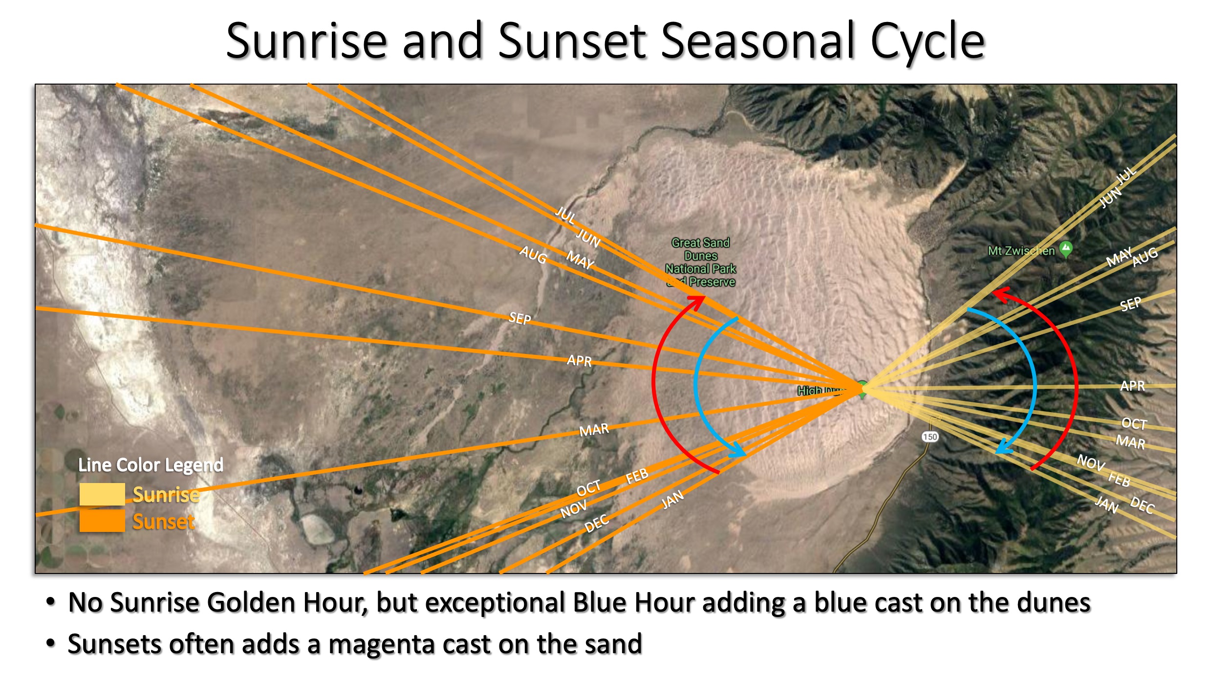
The best time to shoot is whenever the sun is not directly overhead (early morning, late afternoon, or sunset). During those other hours retreat into the woodland to photograph light rays penetrating or backlighting the leaves. Remember that the closer the sun is to the horizon, the larger the shadows will be on the dunes which provide for nice contrast and depth in a photo. However, shadow casting on the Eastern dune field slope occurs after 3 pm. Note that the dune field sunrise golden hour is blocked by the mountains, but the blue hour is extended and offers a blue cast on the dunes. Photographers wanting sunsets won’t be disappointed with the sunset golden hour. Often the sunsets come with a magenta cast to the delight of any photographer. A review of the below seasonal sunrise and sunset cycle helps to calculate the shadow casting angle, as well as, showing a longer delay of sunshine by higher mountain peaks due to the Northern angle of the sun’s position.
What Lenses Do You Need
Will vary depending on the type of photography and composition. Due to the risk of sand getting inside gear, try using zoom lenses that are pre-mounted on a couple of cameras that will cover your planned focal lengths to avoid lens changes. Suggest a range of lenses that cover ultra-wide-angle (16mm – 35mm) to mid-telephoto (70mm – 200mm) for maximum compositional flexibility.
Shot Direction
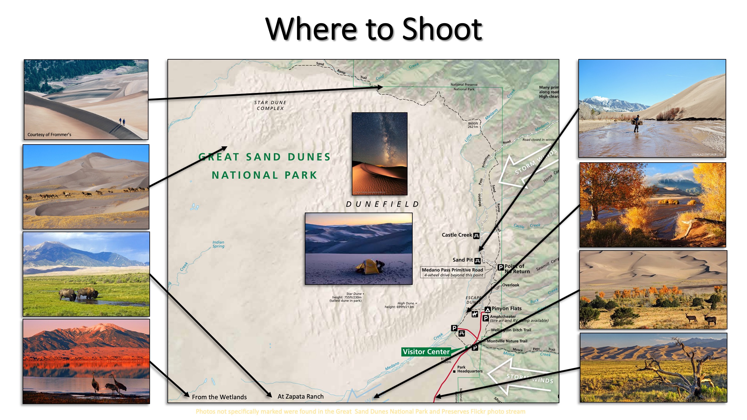
While other types of photography are available, this review will focus on landscape opportunities as illustrated below.
Here are some shooting considerations
- As you enter the park: There are a couple of dead junipers you can use to frame a photo.
- Grasslands: Offer fabulous panoramic opportunities.
- Near the Visitor Center: Allows you to frame photos using the treeline composing the Medona Creek in the foreground or middle ground.
- Medona Pass Primitive Road: Offers access to the Eastern slopes nice fall colors and at the North end an aspen grove with a crossing Medona Creek and closed log cabins.
- Hiking on the ridgeline: Offers greater access to pristine dunes and wide-angle compositions of the dune fields.
- In the Dunefields: Offers exceptional opportunities to pursue contour, texture, and pattern compositions. Milky Way and star shots have a greater impact.
- Westside: Less populated, so expect a higher probability of Elk, Pronghorn, Burrowing Owls, and other animals.
- Wetlands, preserves lakes, and San Luis Lakes State and Wildlife Area: Allows you to incorporate birds and animals or water reflections into the foreground with the dunes and mountains in the background.
- Zapata Ranch: Gives you a chance to bring buffalo and horses into a composition.
Shooting Nuisances
Three nuisances are prevalent to plan for that are also somewhat typical elsewhere.
- Recreator’s interjecting into the image. Recreator’s hiking in the dune field will unintentionally crest a dune from a photographer’s blindside.
- Don’t count on a potential planned composition remaining pristine, because recreators are always hiking in the dune field and leaving behind footprints.
- Wind and Sand. Even a gentile wind can prove to disrupt if it is strong enough to create sand haze or blur the sparse Indian ricegrass, blowout grass, and prairie sunflowers. Note that wind causes blowout grass to make interesting circular patterns in the sand, which is a plus.
Permits
A National Park Pass is required to access the dunes. A 7-day pass can be purchased at the entrance to the Park for $20.
Film & Photo Permits: Commercial use of photos may require a permit. Check park requirements here.
Dunes Camping Permit: Free, but 1st come 1st served.
Backpacking Permits: These are free, but required to track recreators’ whereabouts for emergencies and attendance purposes.
Medano Pass Primitive Road: Traversing into the mountains or over them along this pass requires a free permit.
Special Equipment Needed
Those looking to hike into the dunes should carefully select shoes that will stay dry crossing the Medano Creek and gators to help reduce the chance of sand creeping into shoes as you hike the dunes. Large dunes are like a few other places you will photograph.
Other than photography equipment, make sure you bring a hat, sunglasses, sunscreen, and plenty of water. If you are hiking on the dunes late in the afternoon or evening, bring a flashlight/headlamp and compass and/or GPS to help navigate back to the car as darkness sets in. In addition to protecting yourself, it is important to protect your camera gear. Sand can and will get inside your gear if you are not careful, so bring your camera bag and make sure to cover your gear during wind gusts.
The Great Sand Dunes has the potential for very high winds. On windy days, you should expect to get pelted by fine sand particles while climbing and shooting. Wearing long sleeves and pants will make your experience much more enjoyable.
Consider these other photographic support gear:
- Clear MRC-Nano 007 Filter or a UV Haze MRC-Nano 010M Filter
- Peak Design Shell Medium Form-Fitting Rain and Dust Cover
- Infrared, Bluetooth, or Wifi connecting wireless remote or smartphone remote camera app
- Ground coversheet like the MindShift Gear Contact Sheet Multi-Purpose Tarp
Crowds
Visitation to the Dunes varies based on the time of year, but even during the busiest periods (Memorial Day through Labor Day), the majority of visitors will stay near the Star Dune, which is the tallest dune in the Park and closest to the main parking lot. Staying near this area presents an issue with footprints, so I suggest walking Westward past the crowds or working your way to the ridgeline on the North side to get away from dune hikers. You will not encounter many other photographers outside of the main area.
Traversing Challenges
Getting around the preserve from the parking areas and the main part of the preserve entails using designated unimproved roads or trail areas that range in difficulty from MODERATE to HARD depending upon the trail. The trail difficulty depends on where you shoot.
- Medano Creek and Sand Dune Basin: This entire area is sand, so it is similar to walking on a beach. At certain times of the year, Medano Creek will be flowing across the South basin of the Sand Dunes flat area (particularly in late spring and early summer), but it is usually shallow enough to walk through comfortably.
- Sand Dunes: Hiking into the Sand Dunes is exhausting most times, except in the winter when the ground is often frozen. Expect steep climbs on the sand at elevation rises of over 750 feet. Keep in mind that in sandy exposed areas temperatures in the summer can rise above 150 °F and no cover from sun exposure. The higher elevations at the park mean that sun exposure is more severe which can quickly lead to dehydration and sunburns. Also, remember when hiking in the dunes that there are no designated trail markers – the farther you go from the parking area, the easier it is to lose your path. So, a GPS device or downloaded maps in your smartphone’s navigation app is highly recommended.
- Alpine Trails: These trails offer the photographer access to the beautiful high mountain areas: Music Pass, Sand Creek Lakes, other Alpine Peaks, and Zapata Falls. (Zapata Falls is exceptionally photogenic when frozen in the winter mounts.) These trails also allow photographers a higher diagonal perspective of the dunes. Red osier dogwoods turn a bright crimson color in the fall to contrast the golden beauty of aspen trees. Note: Access to many of these areas require the use of high-clearance 4WD.
- Grasslands and Shrublands: Border the dune field along the valley. During certain times of the season herds of elk and pronghorn are seen grazing. Badgers are found in the grasslands surrounding the dunes on three sides. Careful observers will find burrowing owls. Expect to be able to add interest to your landscape photos during wet summer months when the grasslands become blazed with prairie sunflowers. In the fall compositions can capitalized on the golden flowers found on rubber rabbitbrush in September along with the golden cottonwoods. There are a few juniper trees that can be found isolated in the grasslands that are useful in composition.
- Wetlands: This area offers photographers the best chance to photograph an elk. The use of a telephoto lens will allow picturesque use of the wetlands as a foreground image with the dunes and mountains in the background. A special wetland area, called the sabkha provides beautiful white alkali deposits that can add interest to composition. Expect to find waterfowl, birds, cane, and the unique water shrew in this area.
Accessibility
The visitor center offers a sand dune-capable wheelchair for either an adult or youth, which will require a helper to push.
Hiking and Backpacking
Chief Ranger at 719-378-6321 maintains a list of commercial hiking/backpacking guides authorized to lead trips into the national park and preserve. Click here for the AllTrails available trails.
Weather
The weather in Colorado is normally mild in the summer and cold (lows in the 20s) in the spring and fall. Expect thunderstorms and strong winds during July and August.
Communication & Cell Service
AT&T and Verizon appear to have some signal in the key areas of the park. There are a few places where service is limited to no cell service. Individuals, who frequent low signal areas should consider a car signal booster, like the weBoost Drive Reach, or travel with a satellite communication like the Garmin Inreach. Individuals traveling in a group that plans on being separated in a no-signal area may want to take handheld walkie-talkies. If the added weight is an issue, then consider using GoTennas, which creates a mesh radio system between mobile phones using the GoTenna app.
Lodging
Adjacent to the preserve is the Great Sand Dunes Lodge. More lodging can be found in Alamosa, CO, which is about 30 miles southwest. It is a moderately sized community with several hotels. Prices go up during peak tourist season and on nice weekends outside of the winter months. Lodging requires reserving well ahead.
Camping
There are several camping options on the preserve. Piñon Flats Campground has 85+ campsites and 3 large group sites. Reserve through the Recreation One-Stop system online or contact them by phone at 877 444-6777. Other options require reservations or are on a first-come first-served basis. Click here for a list of nearby camping options.
Dining Options
The Great Sand Dunes Oasis Restaurant is the closest eatery to the preserve, located less than 3 miles from the main gate. Other options require a trip to Alamosa, CO.
Gas Stations
The Great Sand Dunes Oasis is the nearest gas station and convenience store to the preserve.
Charging Stations
Adjacent to the park at Great Sand Dunes Oasis Rv & Camping are some charging stations. While the National Park Services Electric Vehicle Charging Map database doesn’t show any available services, the PlugShare website shows several service locations nearby.
Airport Options
The San Luis Valley’s Regional Airport in Alamosa, CO offers air passenger service to Denver International Airport. Colorado Springs is the next closest regional airport about 3 hours away (servicing American, Delta, Frontier, and United Airlines). Denver is closer to 4 hours but is a much larger airport.
Pets
Pets are permitted in the Preserve (including Mosca Pass Trail) and main use areas of the Park, including Piñon Flats Campground, Dunes Overlook Trail, and along the Medano Pass Primitive Road. They must be leashed at all times and owners must clean up after them. Please carry out waste.
Area Guides and Workshops
- A GREAT resource for photographing the Great Sand Dunes (and all things sand dunes) is the book “How to Photograph Sand Dunes of the American Southwest” written by Rob Strain.
- Colorado Sand Dunes Photography Workshop: August 28-30, 2020 with a Cost: $1,175.
Other Resources
- Great Sand Dunes National Park Link
- Google Map Link to The Great Sand Dunes Visitor Center
- The Photographer’s Ephemeris: A valuable tool for landscape photographers to determine the direction of the sunrise/sunset & moonrise/moonset.
- PhotoPills: This is a fabulous smartphone app with exceptional training resources that will unlock the solar, lunar, and celestial alignment of the Milky Way. It extends to what The Photographer’s Ephemeris leaves off. The augmented reality feature is a great way to ensure your positioning for the composition will materialize as conceived. Watch the video to learn more.
- Alamosa Tourism Information: Know before you go.
- Mountain Photographer: Has documented several trips to this location with over 66 quality photos at this location.
- Outdoor Photographer, Trip Report of the Great Sand Dunes
- The Outbound Collective: 5 Photography Tips for 24 Hours at Great Sand Dunes National Park.
- Photo Guide: Great Sand Dunes National Park | Focal Point: A nice report of her visit to the location.
- Colorado National Park Trips: 4 Places to Shoot in Great Sand Dunes National Park & Preserve
- Photographers Trail Notes: Great Sand Dunes National Park. A great resource to bookmark.
Other Nearby Photography Opportunities
- Alamosa National Wildlife Refuge: A bird and wildlife refuge where you can place the dunes and mountains in the background. This is a refuge that supports the sandhill crane migration.
- Cumbres and Toltec: Historic 1800 steam engine railroad train that runs between Antonito, CO to Chama, NM.
- Monte Vista National Wildlife Refuge: Another wildlife refuge that offers a wetland area with birds.
- San Luis Lakes State and Wildlife Area: A lake in the Southeast corner of the perverse area that is a habitat for waterfowl and animals. It also offers a chance to use as a foreground to a dune’s composition.
- Shrine of the Stations of the Cross: A beautiful historic catholic parish. The Stations of the Cross offer visitors a series of graphic meditations of the last hours of Christ’s life – His judgment, sufferings, death, and resurrection.
- Zapata Falls: A nice waterfalls and stream. The falls when frozen are very captivating. Primitive campgrounds are located nearby and managed by the state.
- Zapata Ranch: Offers a chance to incorporate buffalo into a composition. This ranch is owned by the Nature Conservatory and offers accommodations and ranch vacations.
Closure
The Great Sand Dunes National Park and Preserves offers photographers with a plethora of photographic options, interesting lighting and color tones, and several recreational opportunities to pursue. This guide should help you gain the most out of your visit and shorten your planning research requirements.
Get this post as a PDF

